Desert Civilization
At the beginning of the 17th century, Kuwait was known as Guerin (or Grain), from the Arabic words Garn (high hill) and Kut (fortress). Some historians claim that Barrak Bin Gurayf, a sheik from the Bani Khalid clan, built Kuwait in Grain and that the city has since received its current name.
Location
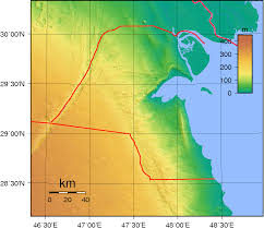
Kuwait is located in the northwest corner of the Arabian Gulf, between 28 and 30 degrees latitude and 46 and 48 degrees longitude. To the north and west, it shares a border of 240 km (149 miles) with the Republic of Iraq, and to the south and southwest (250 km or 155 miles) it borders the Kingdom of Saudi Arabia. In the east, it is washed by the waters of the Arabian Gulf (the coastline is 290 km or 181 miles).Area and topography
The total area of the State of Kuwait is 17, 818 km2. Most of the territory is a flat desert, gradually descending to sea level in the east. It is divided by small depressions and low hillsthat form the Jal Az-Zor mountain range (145 meters above sea level), cut by Umm Al-Ramam Wadi. This area is known among the locals as Godai, which means hill. Southern Kuwait is mostly flat, with the exception of Ahmadi Hill, whose height is 137 meters above sea level. Kuwait, where there are no mountains, rivers or other natural features, has long served as a transfer point for tribes and caravans. Such freedom of movement made it difficult to draw borders. On July 7, 1965, a neutral territory was created between the state of Kuwait and the Kingdom of Saudi Arabia. The northern part of the separated territory was controlled by Kuwait and the southern part by Saudi Arabia. Both countries share equally the oil produced in this territory.
Territorial waters
bay. The area of Kuwaiti territorial waters totals about 2,200 square meters. miles It can be divided into two parts - a shallow northern part with a silty bottom, the depth of which in many places does not exceed 5 meters and a relatively deep southern part with a sand-silicon bottom. Most Kuwaiti ports are located in the southern part due to its deep waters
coast
There has always been a close connection between Kuwait and the sea, this connection has formed a characteristic feature of the inhabitants of today's Kuwait and was the main source of income in ancient times. Despite the fact that today the picture has changed a lot thanks to urbanization and modernization, the connection with the sea still remains a memory of the past for Kuwaitis. The 290-kilometer coast can be divided into two main parts: it stretches along the Arabian Gulf, and the other goes around the Kuwaiti bay and Khor
Subiya. The first part consists mainly of sandy beaches, while the second, 70 km long, is flooded at high tide, especially in the shallow northern part of Kuwaiti bay, where the maximum wave height is 16 cm. In Kuwait, there are six ports in Shuweikh, Doha, Ahmadi, Mina Abdullah, Shuayba and Az-Zor, in addition to them there are several anchorage sites used by individual companies or individuals and 20 anchorages for small vessels. 11 percent of the beaches are for tourist recreation and entertainment, 40 percent of the coastline is used by special organizations and citizens for private villas and chalets, 35 percent of the beaches, mainly in the northern part, remain untouched. used by individual companies or individuals and 20 anchorages for small vessels. 11 percent of the beaches are for tourist recreation and entertainment, 40 percent of the coastline is used by special organizations and citizens for private villas and chalets, 35 percent of the beaches, mainly in the northern part, remain untouched. used by individual companies or individuals and 20 anchorages for small vessels. 11 percent of the beaches are for tourist recreation and entertainment, 40 percent of the coastline is used by special organizations and citizens for private villas and chalets, 35 percent of the beaches, mainly in the northern part, remain untouched.
Subiya. The first part consists mainly of sandy beaches, while the second, 70 km long, is flooded at high tide, especially in the shallow northern part of Kuwaiti bay, where the maximum wave height is 16 cm. In Kuwait, there are six ports in Shuweikh, Doha, Ahmadi, Mina Abdullah, Shuayba and Az-Zor, in addition to them there are several anchorage sites used by individual companies or individuals and 20 anchorages for small vessels. 11 percent of the beaches are for tourist recreation and entertainment, 40 percent of the coastline is used by special organizations and citizens for private villas and chalets, 35 percent of the beaches, mainly in the northern part, remain untouched. used by individual companies or individuals and 20 anchorages for small vessels. 11 percent of the beaches are for tourist recreation and entertainment, 40 percent of the coastline is used by special organizations and citizens for private villas and chalets, 35 percent of the beaches, mainly in the northern part, remain untouched. used by individual companies or individuals and 20 anchorages for small vessels. 11 percent of the beaches are for tourist recreation and entertainment, 40 percent of the coastline is used by special organizations and citizens for private villas and chalets, 35 percent of the beaches, mainly in the northern part, remain untouched.
.


.jpg)

No comments:
Post a Comment
Please Dont Enter Any Spam Link in The Comment Box